Each year, coastal communities in Western Alaska watch feet – even yards – of shoreline disappear into the waves. Now, a new online mapping tool will let them look at past erosion and see where coastlines might be in future years.
In the next ten or twenty years, the waters of Bristol Bay will overtake much of Port Heiden’s old, abandoned village site. It’s a fate that’s long been obvious to residents of Port Heiden. And now anyone with an internet connection can see the water’s progress over time using the new Alaska Shoreline Change Tool.
“On the west side, that’s where the shoreline’s about 5 feet away from that building.”
Scott Anderson is the Mayor and Environmental Coordinator for the City of Port Heiden. I spoke to him over the phone as we both clicked our way around the interactive map.

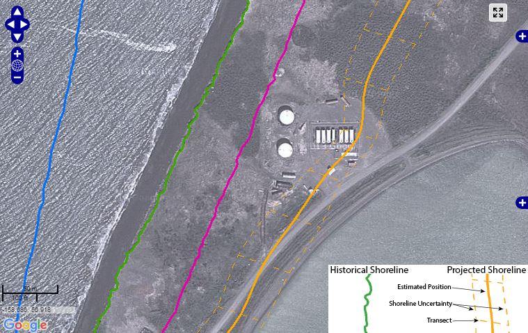
A satellite image shows a bird’s eye view of Port Heiden. It’s overlaid with a series of colored lines that you can toggle on and off to show exactly where the shoreline was during a given year — from 1957 to the present, with predictions up through 2035. Anderson tells me the satellite image is an old one. Some of the buildings are already gone, hauled away from the creeping coastline.
“You see where the two white tanks are?” asked Anderson. “The shoreline – it’s now about halfway through that tank closest to the west.”
A few years ago, Anderson called on the Alaska Division of Geological and Geophysical Surveys (DGGS) to study Port Heiden’s erosion. The village needed help to haul away old buildings before they crumbled into the bay. And they needed better information about how fast the erosion was going to keep happening.
“So, we did some fieldwork for Scott in 2013.”
Alex Gould is a geologist for DGGS who created the Alaska Shoreline Change Tool. He says the erosion survey that Anderson asked for in Port Heiden became a model for similar mapping efforts elsewhere;
“We then decided, oh, we can apply this across the state,” says Gould.
Over the last year, Gould created clickable shoreline maps for Unalakleet, Wales, Kivalina, and four other locations on the Beaufort and eastern Chukchi sea coasts. He says mapping the shoreline change over time required aerial photographs.
“A lot of the old ones are Air Force and Navy… So they’re taken with a plane that’s specially set up to have a camera pointed straight down,” explained Gould. “A lot of these photographs are housed by USGS and some by the UAF. They went and they scanned all these old photographs… we have to process the imagery first before we can actually map the shoreline.”
Gould says he chose to make an interactive web map because some shorelines are changing so quickly that his team couldn’t publish print maps often enough.
“So with an interactive interface, we can continually add data and allow it to be much more fluid, rather than printing out a solid map,” he said. “So that’ll be really important because the data we’re going to be getting in the near future – year two – will be incorporated right away into these maps.”
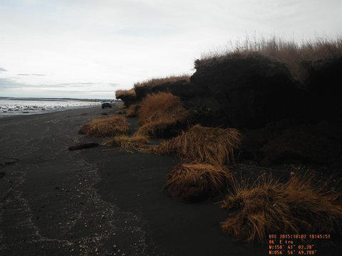
Back in Port Heiden, Mayor Anderson is on board with that plan. He took photos after an early fall storm to give the DGGS team an update. He says the maps have already helped Port Heiden catch the attention of state and federal agencies who can help fund backhaul efforts. And the online tool is an added benefit.
“Anybody now, I mean, just like you and I are sitting here talking about it, we can say – ‘You see exactly what I’m talking about. And I can give you a picture that proves it.’” says Anderson. “So it’s a pretty handy tool. It’s pretty awesome.”
The Shoreline Change Tool went live last month, but the DGGS has plenty more erosion data to work with. Gould says in the coming year he may add online maps for Shaktoolik, Nome, and Hooper Bay, among other communities.
The map project was funded by the U.S. Fish and Wildlife Service’s Coastal Impact Assistance Program. The DGGS also published a guide to accompany the interactive map tool.