As a significant fall storm approaches Western Alaska, the state Department of Homeland Security and Emergency Management is asking residents to prepare as best they can to protect life and property.
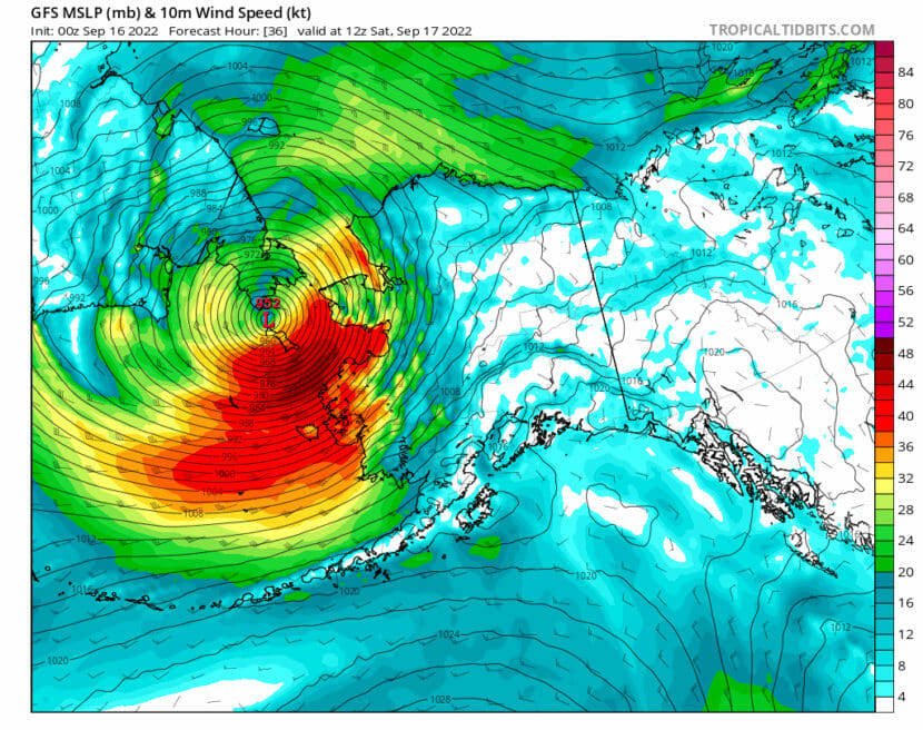
What’s left of Typhoon Merbok is on a textbook track into the Bering Strait, said Ed Plumb, a meteorologist with the National Weather Service Office in Fairbanks.
“The remnants of that [moved] up into the Bering Sea Thursday, and then move northeast and track towards the Bering Strait,” Plumb said, “And then into the Chukchi Sea through Saturday.”
Thursday night, seas were as high as 41 feet in the Western Aleutians, according to the National Weather Service in Anchorage.
Because the storm is estimated to bring high winds and coastal flooding later today, DHSEM is urging communities and residents to make last minute preparations now. Claude Denver, the response manager for the state emergency operations center, said people in Western Alaskan should secure large equipment or loose materials, stock up on drinking water and check on their neighbors in need.
“We expect that there may be up to 90 mph gusts. The same kind of weather conditions that would complicate flying, would complicate any kind of aerial delivery of materials or response. So that’s something to keep in mind. For most communities, while the storm is going on, folks have to employ your local emergency plans in preparation to kind of get through the first 48 to 72 hours of the event,” Denver said.
The strongest wind gusts are expected later tonight along with rapidly increasing storm surge throughout the night.
https://twitter.com/AlaskaWx/status/1570844633458155520?s=20&t=uek9G_8O2K4vbYnU8yS_JA
This applies to communities along the Yukon Delta Coast, the Norton Sound, and throughout the Bering Strait. The peak storm surge could rival the Bering Sea superstorm from November of 2011. But without any sea ice to buffer coastal communities this time around, Plumb says it could cause severe coastal flooding.
“The highest storm surge is going to be in the Northern Bering Sea. We’re looking at storm surge values from 8 to 12 feet over portions of the Southern Seward Peninsula and then down further south, towards the Yukon Delta, 5 to 8 feet,” Plumb said.
Based on historical climate records in Alaska, going back over the last hundred years, this could be the strongest September storm ever recorded in the Northern Bering Sea, according to NWS.
Denver emphasizes that for now, communities should activate their emergency response plans. But once the storm settles down, then the state will respond with the appropriate resources, Denver said.
“We’re really not quite sure what the impact is going to be,” Denver said. “So we really want to make sure that if something happens in a community, if they could reach out to us, the State Emergency Operations Center at (907)428-7100, and let us know what they find; if there’s flooding, if there’s damage, [high] winds, resource needs, if they’ve got people sheltering, if the power is out.”
For more detailed information on what local impacts this storm could have in your community, go online to NWS Fairbanks’ Facebook page.


