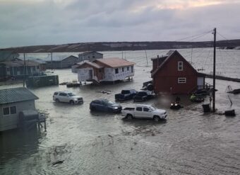
A storm is on track to hit a portion of the area pummeled last month by the remnants of Typhoon Merbok. National Weather Service meteorologist Scott Berg said the new storm developing in Russia is anticipated to move north of the Siberian Peninsula toward Alaska midweek.
“And as it does that, it’s going to bring some strong southwesterly, south winds into areas —basically areas from Norton Sound north to Point Barrow,” he said.
Berg said as the front makes it inland, winds will turn more westerly, and some storm surge is expected.
“We’re looking right now at it being basically minor coastal flooding, but there could be quite a bit of erosion with the wind waves on top of the surge that may occur,” he said.
Berg said erosion could be worse due to damage done by last month’s major storm.
“Their defenses are down,” he said. “The berms that were built up over the years, have all been damaged, so any minor coastal flooding or high surf in those areas could cause erosion issues that will be a bigger impact than what they normally would be.”
A special statement from the National Weather Service says strong winds are expected to move into the Eastern Bering Sea and Chukchi Sea Wednesday afternoon with an elevated risk of coastal flooding from the Bering Strait to Point Hope Wednesday night into Friday. It says high surf is possible on south and west facing shores of Norton Sound.


