Alaska had its 17th warmest calendar year on record in 2022, while the rest of the globe saw its fifth warmest year in recorded memory. That’s as the average global ocean temperature continues to break records, as it did again last year.
National Weather Service climate researcher Brian Brettschneider is back for our Ask a Climatologist segment.
And Brettschneider says that even if Alaska’s temperatures didn’t shatter any major records in 2022, it’s important to remember they’re still far higher than they used to be. We’ve been lucky, as he puts it, to have had three La Niña years in a row. But that’s probably about to change.
Listen:
The following transcript has been lightly edited for clarity.
Brian Brettschneider: Typically, again, in a La Niña year, our part of the world is generally cooler than the global average. And so when we say, “Oh, you know, 17th doesn’t sound too bad, it’s not the apocalyptic terms that we often hear,” it is important to keep that regional-versus-global perspective in mind.
Casey Grove: Gotcha, yeah. I saw a tweet from you recently talking about that, where, even if it’s a La Niña year, it can still be a pretty significantly warm year. But we should watch out for the next time an El Niño comes around. What did you mean by that? And what could we expect, potentially, in the next El Niño year?
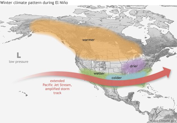
Brian Brettschneider: Well, Alaska pretty consistently has cooler than normal La Niñas. But as you indicated, there’s more variability, so we can have warmer than normal La Niñas. Maybe about two-thirds of them are cooler than normal. El Niños, on the other hand, are uniformly warm in Alaska. El Niño years, the question is, are we going to be warm, really, really warm or record warm? That’s kind of the options that we have in an El Niño year. And, you know, the trends now, the latest outlook from the Climate Prediction Center, favors us moving out of La Niña into what we call “ENSO (El Niño-Southern Oscillation) neutral,” and even has a tilt toward possible El Niño conditions developing in the fall. So there’s a lot of agreement on that, but it’s a ways out. You know, they’re cautious in their language. But the indications are that that might be where we’re headed.

Casey Grove: That’s interesting. I mean, that seems like a long ways away from here. What sort of indicators are pointing toward that?
Brian Brettschneider: Well, so both the statistical and the dynamic models that are looking at the evolution of the trade winds in the tropical Pacific, some of the ocean current movement, the subsurface ocean heat content, all of those are trending in a direction that would indicate certainly that we’re going to leave the La Niña condition. But we could really flip the switch and go toward an El Niño.
Casey Grove: So I’m glad you mentioned the ocean temperatures, because I wanted to talk about that. I saw another headline here recently that, again, globally, we broke the record, again, for the temperature in the ocean going up. What does that mean, in the greater context of all the other indicators that we have that the climate, globally, is warming?
Brian Brettschneider: From year to year, we do have variability, and we have parts of the climate system that will look kind of jumpy if you look at a time series. And a great example of that is La Niña. So we’ve had a couple of La Niña years in a row. And that generally affects up to maybe say, the top 100 meters of the ocean, where, you know, the wind patterns and upwelling of water alongside the coast of South America, you know, it can favor a cooling of that surface. But that’s just the very top layer. The ocean is a great, kind of, like a sponge for absorbing atmospheric heat. And when we look at greater depth — so not just the very top surface, which is affected by year-to-year variability — we look at the top 2,000 meters, those top 2000 meters are absorbing just a tremendous amount of warmth from the atmosphere. That doesn’t change very much year to year. There’s not much variability. The way that it does change is it keeps absorbing more heat. And so it’s a very constant, upward trend, and 2022 broke the record for ocean heat content that was just set in 2020, which broke the record from the year prior. So a very, very linear trend line. And we would expect 2023 is going to break the record that was set just last year. And the oceans absorb about 90% of the excess warmth that’s being trapped by the atmosphere. So this is warmth that’s going to stay around for a long time to come.


