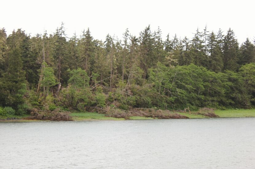
If you look across Auke Nu Cove from the parking lot at the Juneau ferry terminal, there’s a strange patch of fallen trees — about a dozen — that are splayed out in all directions.
Jesse Escamilla drives by on his evening commute every day. He’s used to seeing the occasional downed tree around his Lena Point home, but the fallen trees at Auke Nu Cove seemed mysterious and distinct.
“It looked odd, like it was isolated,” he said. “I remember it almost looking like someone with a bulldozer went and purposefully flattened that whole area.”
Escamilla grew up in Texas, and the pattern reminded him of the mark tornados leave. That became one of his two working theories.
“Option one would be Godzilla, and option two would be a tornado,” he said. “Both of those are viable, in my opinion.”
National Weather Service Meteorologist Rick Fritsch says the fan of fallen trees could be evidence of one of Juneau’s weirdest wind phenomena.
“To me, that sounds a whole lot like a microburst,” Fristch said.
The Southeast Alaska Land Trust manages the wetlands by the trees. Their conservation staff said the trees came down during a major wind storm that happened in October 2021.
That storm blew down dozens of trees across town. They hit houses and crushed cars, and in some neighborhoods they caused days-long power outages. It took days to clean up the mess of scattered trunks and branches.
The strong winds spread across all of Juneau. But in the small area around Auke Nu Cove, the wind may have generated a microburst, which can cause distinctive damage.
Fritsch says a microburst starts with a really strong gust of wind that blows straight down from the sky.
“And it comes down on the ground and it hits and goes out in every direction,” Fristch said.
As the winds gush outwards, they can exceed 100 mph — typically causing a lot of damage in a very small area. Just like what Escamilla noticed at Auke Nu Cove.
Elsewhere, microbursts are often associated with thunderstorms. When a thunderstorm forms, a swell of warm air rises to create clouds, which get heavy as they fill with rain or hail. If they get too heavy, they can release a strong gust of air that speeds toward the ground. That’s a microburst.
But thunderstorms are rare in Juneau, and that’s not what happened in the October storm. The alternative is even more interesting. It has to do with how wind interacts with Juneau’s coastal mountains.
“We in the business talk about straight-line winds, microburst winds and cyclonic winds, which are more associated with tornadoes. Basically circular,” Fritsch said.
Wind has basic, somewhat predictable directions, too. During a high pressure system — the kind that’s associated with clear skies — winds spiral clockwise and outwards to form gentle breezes. When a stormy, low-pressure system forms, winds spiral counterclockwise and inwards, building speed as they turn.
Those are the basics, but they’re not enough to predict exactly how the wind will behave.
“How do you get these winds flowing the way they do?” Fritsch said. “The topography on the inside is everything.”
Wind — like all weather in Southeast Alaska — is heavily influenced by topography.
Take straight-line winds. They’re strong storm winds that blow in just one direction. In stormy weather, they race down Gastineau Channel.
“So there’s sea level there. And then we got 3,000 feet on this side and 2,500 feet on this side,” Fristch said, pointing to downtown Juneau and Douglas on a map. “And that just acts like a natural funnel.”
That funnel directs strong gusts across Mendenhall Peninsula and up the runway at Juneau International Airport — in the case of that October storm, for nearly 24 hours. It kept planes on the ground, and it pushed many of the trees at the end of the runway to their breaking point.
Straight-line winds caused most of the tree falls during the storm, but the mystery treefall at Auke Nue Cove can probably be linked to what’s called the mountain wave phenomenon.
When wind hits a mountain, it’s forced upward. Then it hits a mass of stable air high in the sky, which pushes it back down. Those opposing forces make the wind move in an up-and-down wave motion.
When there are really strong winds and a stable air mass around Gastineau Channel, that wave action creates the famed Taku Winds in downtown Juneau.
But mountain waves can also cause microbursts. In some cases, clouds form under the mountain waves. When the windy waves pass over the top of a cloud, the friction can cause the cloud to start turning.
“You can’t necessarily see it spinning, like a sideways tornado,” Fritsch said. “But it is rotating. That’s the rotor cloud.”
On the side of the rotor cloud by the mountain, there are strong updrafts; on the far side, strong downdrafts. As gusts come over the mountains, they can get caught in those rotor clouds, spiraling and speeding up into the downdraft side of the cloud. And that downdraft can break away and come down as a microburst.
When that happens, it has the potential to cause Godzilla-sized damage. Fritsch isn’t sure that’s what took down the trees at Auke Nu Cove, but he says it’s the natural explanation.
“It may have been that you had this air that hit the Mendenhall Peninsula, and it rose, and it got trapped in a rotor,” Fritsch said. “And on the far side of the rotor, it went straight down.”
Fritsch said the wind is leaving its mark on Alaska’s landscape every day.
“Somewhere, there will be some kind of wind anomaly in the great, huge, awesome state of Alaska that will probably go unnoticed,” he said. “Because there’s nobody there to see it.”
Curious Juneau
Are you curious about Juneau, its history, places and people? Or if you just like to ask questions, then ask away!


