This is a developing story. Check back for updates.
KTOO’s livestream coverage has ended, but an archive will be available here.
Update, 1 p.m.:
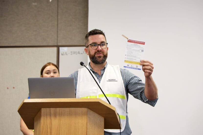
During a press briefing Friday morning, members of the 2025 Juneau Glacial Lake Outburst Flood Joint Information Center provided status updates on flood recovery efforts in the Mendenhall Valley.
Juneau Mayor Beth Weldon and Central Council of the Tlingit and Haida Indian Tribes of Alaska President Chalyee Éesh Richard Peterson both shared their appreciation for local responders and relief that damage in this year’s flood was minimal compared to last year.
An official shared that debris pickup will begin Monday to allow residents more time over the weekend.
According to the city’s website, “Crews staffed by Tlingit & Haida, CBJ, and community volunteers will make a first round of debris collection from flood-impacted neighborhoods on View Drive, Marion Drive, Meander Way and Meadow Lane starting Monday, August 17 at 8 a.m. Please move your debris to the right of way for crews to pick up.”
Sabrina Grubitz, Tlingit & Haida public safety manager, shared resources for residents in need of assistance, including the recovery hotline — 1-844-445-7131 — and ready.alaska.gov where residents can apply for state individual assistance via web application. The deadline to apply is Oct. 14.
Ryan O’Shaughnessy, Juneau’s emergency manager, outlined the city’s initial damage assessment over more than 700 homes in the affected area with breakdowns based on damage level. Sixteen homes saw a relatively small amount of water in a garage or crawl space, categorized as “affected.” Another 25 homes saw a “minor” amount of damage extending into living space but not affecting electrical wiring.
Six homes saw major damage. Of those, only one was within the area protected by the city’s HESCO barrier. The rest are located on View Drive, which is not protected by the barrier.
O’Shaughnessy said there are some unverified homes that have been visually assessed from the public right of way but where city staff have not been able to contact the owners.
“It’s clear that the HESCO barrier project has saved hundreds of homes from that damage,” he said.
Nate Rumsey from the city’s Public Works department said staff are continuing to assess damage to the HESCO barrier. Several areas saw damage due to debris strikes, including a 15-foot section of the barrier by Dimond Park Field House that was most likely taken out by a tree.
South Coast Region Director for the Alaska Department of Transportation Christopher Goins said a section of the Back Loop Bridge was lost during flooding. Crews are starting work on the repair tomorrow but they do not have a timeline for when the bridge will reopen.
Update, Friday 10:30 a.m.:
The 2025 Juneau Glacial Lake Outburst Flood Joint Information Center will hold a press briefing at 11 a.m. Tune in above.
Update, 2 p.m.:
The United Way is set up in Melvin Park in the Valley from 10 a.m. to 7 p.m. Thursday and Friday to help residents impacted by flooding with requests for volunteer help with everything from pulling out wet insulation to moving sandbags. They can also provide meals.
Update, Thursday 11 a.m.:
The 2025 Juneau Glacial Lake Outburst Flood Joint Information Center held a press briefing at 10:00 a.m.
Officials said the river level has fallen to around 5 feet. Back Loop Bridge is still closed after floodwater scoured part of the bank. The Alaska Department of Transportation says the bridge will remain closed while they asses the damage.
No residents lost access to drinking water during the flood and there are no pollution concerns, according to the Alaska Department of Environmental Conservation.
Officials also shared that 30 residents of Riverview Senior Living, which sits along the Mendenhall River, were evacuated during the flood to a local church. About 20 residents stayed with local friends or family.
As the damage assessment becomes more clear, local officials will provide more information on individual assistance on Friday.
Update, 3 p.m.:
Emergency officials issued an alert that the flood threat has ended and evacuated areas are now open to residents only.
Back Loop Bridge remains closed, but power has been restored to most of the affected area.
The river level has receded to minor flood stage.
Update, 10:15 a.m.:
The flood zone remains under an evacuation advisory, but Capital City Fire/Rescue Assistant Chief Sam Russell said during a press conference that emergency responders did not need to make any rescues overnight as waters levels rose.
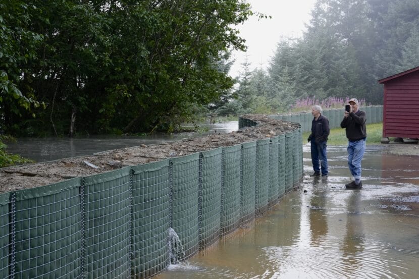
Ryan O’Shaughnessy, Juneau’s emergency manager, says AEL&P is starting to restore power to affected areas. He also said officials are continuing to assess the HESCO barriers. City officials say the barriers protected homes that would have otherwise been more severely damaged by record-breaking flood levels, even though some flooding still occurred. Damage is still being assessed.
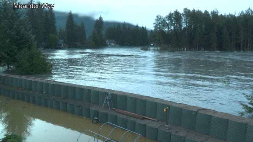
KTOO’s Clarise Larson shot this footage from Meander Way this morning.
Update, 9:30 a.m.:
The water level continues to drop on Mendenhall Lake and River. The current gauge level is 14.5, which means we remain in major flood stage. The National Weather Service says water is receding quickly and should reach minor flood stage later this afternoon.
Once again, the 2025 Juneau Glacial Lake Outburst Flood Joint Information Center will hold a press briefing at 10:00 a.m. KTOO will carry the briefing live on 360TV, on the radio and here via the livestream.
Update, 8:00 a.m.:
The National Weather Service has confirmed that the river crested at 16.65 feet a short while ago and water levels are now dropping.
Read the latest update here.
Update, 7:45 a.m.:
The 2025 Juneau Glacial Lake Outburst Flood Joint Information Center will hold a press briefing at 10:00 a.m. KTOO will carry the briefing live on 360TV, on the radio and via livestream.
“Today’s briefing will provide an update on the status of the flooding, actions taken by the Unified Command over the last 24 hours, as well as overview of planned next steps,” the media release states.
Update, 7:15 a.m.:
The City and Borough of Juneau wants residents to avoid driving on flooded streets.
The flood barriers continue to hold, but water is being observed seeping around them.
Update, 6:30 a.m.:
AEL&P has cut power to parts of the Mendenhall Valley as flood waters continue to rise.
Update, 6:00 a.m. Wednesday:
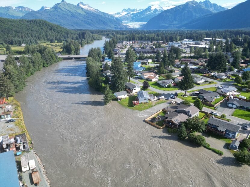
The sun is up over the Mendenhall Valley as the water level on Mendenhall River currently stands above 16 feet — a new record for glacial outburst flood height in Juneau.
The river reached major flood stage around 1 a.m. and is still forecast to peak later this morning between 8 a.m. and noon. There are reports of water seeping under the temporary levee and water on some streets in the Valley.
Send any observations or pictures you’d like to share from your neighborhood to news@ktoo.org.
Update, 7:00 p.m. Tuesday:
The National Weather Service has updated its forecast for when the glacial outburst flood will crest. As of this evening, a crest somewhere between 16.25 and 16.75 feet is expected between 8 a.m. and noon Wednesday.
The initial flood forecast estimated a peak of around 16.6 feet on Wednesday afternoon.
Water levels are expected to go above major flood stage of 14 feet early Wednesday morning.
Update, 4:00 p.m. Tuesday:
The Juneau School District is canceling all extracurricular and school-sponsored events Tuesday and Wednesday.
The district is also closing Kax̲dig̲oowu Héen Elementary School, Mendenhall River Community School and Thunder Mountain Middle School at 4 p.m. today until the City and Borough of Juneau issues an all clear.
The district has not yet made a decision on closing schools on Thursday — the first day of school. It will make an announcement by Wednesday at noon. If any schools need to close, the district will close all campuses.
Update, 11:10 a.m. Tuesday:
During an 10 a.m. press conference, local officials shared public safety updates.
Nicole Ferrin, the warning coordination meteorologist at the National Weather Service in Juneau, said the record peak of 16.6 feet is expected sometime Wednesday afternoon.
“This will be a new record based on all of the information that we have,” she said.
Ryan O’Shaughnessy, Juneau’s emergency manager, asked residents to stay away from the river and bridges. Backloop Bridge will close at 8:30 p.m. Tuesday.
“This is a very dangerous situation,” he said.
On Monday, the city hung nearly 900 informational door flyers in Mendenhall Valley neighborhoods in the flood zone and launched a flood information hotline.
“There’s no need to rush out of neighborhoods, but we encourage folks to take a moment, take a deep breath, and remember that they have a plan,” O’Shaughnessy said. “This is something that we’ve been planning for as a community.”
Capital City Fire/Rescue Assistant Chief Sam Russell said emergency responses will become more difficult as the river rises.
“As the flood goes up, our ability to navigate the waters goes down due to the debris that flows down through it makes navigating the river with a boat very, very difficult,” Russell said. “Please stay away from the river as much as possible.”
Update, 10:45 a.m. Tuesday:
The Juneau School District will make a decision on closing schools by Wednesday at noon. The district plans to close all schools if any campuses will be impacted by flooding.
Superintendent Frank Hauser said during a press conference Tuesday the district is requesting families update contact information in PowerSchool to ensure they receive the most recent updates from the district.
Update, 9:45 a.m. Tuesday:
Juneau’s glacial outburst flood has begun.
Just before 9:30 a.m. on Tuesday, the National Weather Service issued a flood warning and initial flood forecast of around 16.6 feet for Mendenhall River. That record peak is expected Wednesday afternoon.
This comes as the river is already in a minor flood stage due to significant rainfall over the past few days. The weather is expected to be dry Tuesday afternoon and Wednesday.
The forecast is subject to change. Typically it takes a day for the National Weather Service to see how fast the water is moving and adjust the forecast accordingly.
The City and Borough of Juneau issued an emergency alert via text that told residents in the flood zone that “evacuation is advised. Stay clear of rivers.”
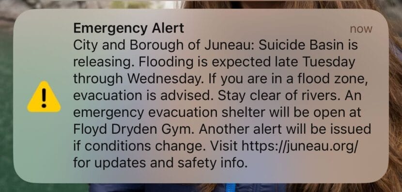
An emergency evacuation shelter will be at Floyd Dryden Middle School later on Tuesday.
Update, 2:30 p.m. Monday:
City and tribal officials say they will begin hanging informational door flyers in Mendenhall Valley neighborhoods in the flood zone and launch a flood information hotline Monday afternoon.
The door hangars warn residents that the basin is full and that an emergency shelter will be available at Floyd Dryden Middle School once the flood begins. It also includes advice on how to protect property.
Aaron Jacobs, the senior service hydrologist at the National Weather Service in Juneau, gave an update on Suicide Basin at a press briefing late Monday morning. Suicide Basin reached full capacity and began spilling over the top of the glacier Sunday night.
“At this time there is no signs that the release has taken place,” he said.
He said Monday’s rainfall will likely continue to raise water levels in Mendenhall River and Lake, which could affect the flood height once water does start releasing. But, he expects the precipitation to slowly drop off through Monday evening and into Tuesday.
“I know there’s been some reports of a waterfall being seen at the face of the glacier, and that is what we’re seeing. There is just a general glacial flow in the runoff that we’re seeing from the precipitation and just the regular melt from the Mendenhall Glacier,” he said.
Ryan O’Shaughnessy, Juneau’s emergency manager, said the city continues to advise people to prepare to evacuate. They have not issued a mandatory evacuation order, but officials highly recommend people leave once the flood warning is issued. This year’s flood will be the first test of the flood barrier the city installed this spring.
“We have a lot of confidence in the mitigation measures that have been put in place — that being said, this is not something that we want to gamble with,” he said. “The message to carry across please, is to ‘Yes, evacuate if you do get that notice.’”
The state’s Department of Transportation & Public Facilities is preparing for potential bridge and road closures along the river. Officials say when and where will depend on the height and timing of the flood.
Original story:
The countdown has begun for Juneau’s annual Glacial Lake Outburst Flood. Suicide Basin reached full capacity and began spilling over the top of the glacier Sunday night.
That means flooding could begin any day.
The National Weather Service issued a special weather statement indicating that it could take up to six days for the basin to release floodwaters into Mendenhall Lake.
Once the water level in Mendenhall Lake begins to rise, the National Weather Service will issue a flood warning. From that point, it will take about 48 hours for the floodwaters to crest in the Mendenhall River.
The City and Borough of Juneau issued an emergency text alert just after 8 p.m. that notified Juneau residents that the basin was overtopping.
“Now is the time to make last-minute preparations, finalize evacuation plans, and pack a go-bag,” the alert stated.
Aaron Jacobs, the senior service hydrologist at the National Weather Service in Juneau, said that the contingency forecast is a 16.5-foot flood — that’s subject to change. Jacobs said to check the Suicide Basin monitoring page for an updated forecast once the release begins and as it progresses.
The contingency forecast is based on estimates that Suicide Basin has expanded compared to prior years and that the ice dam holding back the water is a bit lower.
That forecast is also based on the past few days of increased rainfall, which have raised the water levels in the lake and river. Jacobs said the rain could affect the flood height if it doesn’t flow out to sea before the basin releases.
“So we’re hoping that the basin will not release at this time in the next day or so and then the Mendenhall levels can come back down to more normal levels,” he said.
The city will issue another emergency text alert when the National Weather Service issues a Flood Warning. That will mean that the basin is releasing and the flood has begun.
KTOO’s Alix Soliman, Clarise Larson, Adelyn Baxter and Jamie Diep contributed.
